


US Topo Maps
US Topo Maps의 설명
미국 최고의 지도와 항공 사진을 무료로 이용할 수 있는 사용하기 쉬운 야외 내비게이션 앱입니다.
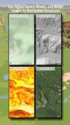
30개 이상의 지도 레이어(토포스, 항공, 해도 등) 중에서 선택하여 완벽한 여행을 계획하고
오지로의 오프라인 여행을 위해 Android 휴대폰/태블릿을 실외 GPS로 전환하세요.
다른 소스(GeoPDF, GeoTiff, WMS와 같은 온라인 지도 서비스 등)의 지도를 쉽게 추가하세요.
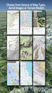
미국에서 사용 가능한 베이스맵 레이어:
• USGS 국가지도 Topo
• USGS 국가 지도 이미지 Topo
• USGS 국가 지도 이미지
• USGS NAIP HiRes 이미지
• USGS Topo 기존 DRG: 축척 1:250.000, 1:100.000, 1:63.000 및 1:24.000/25.000에서 미국 지형도를 완벽하게 포함합니다.
• FSTopo 숲 지도
• NOAA 해상 RNC 차트
• 국가 고도 지도(Hillshade, Slope 지도, Aspect 지도)
전세계 베이스맵 레이어:
• OpenStreetMaps(5가지 지도 레이아웃), 공간 절약형 벡터 형식으로도 다운로드 가능
• Google 지도(위성 이미지, 도로 및 지형 지도)
• Bing 지도(위성 이미지, 로드맵)
• 밤의 지구
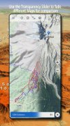
베이스맵 레이어를 오버레이로 구성하고 투명도 페이더를 활용하여 지도를 서로 원활하게 비교할 수 있습니다.
다른 소스에서 지도를 추가합니다.
• GeoPDF, GeoTiff, MBTiles 또는 Ozi(Oziexplorer OZF2 & OZF3)에서 래스터 지도 가져오기
• WMS 또는 WMTS/Tileserver로 웹 매핑 서비스 추가
• OpenStreetMaps를 벡터 형식으로 가져옵니다. 예를 들어 몇 GB만 있으면 미국을 완성할 수 있습니다.
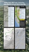
사용 가능한 미국 지도 오버레이 - 다른 기본 지도에 추가 정보를 추가하세요.
• 공공 토지 소유권(PAD-US 3)
• 국가 수로 데이터 세트
• 자동차 사용 지도(USDA)
• 고도 등고선
• 4WD 트레일
• 트레일
• 도로, 철도, 공항
전 세계적으로 사용 가능한 오버레이:
• 음영기복 오버레이
• 20m 등고선
• 오픈씨맵
완벽한 지도는 없습니다. 다양한 지도 레이어 사이를 전환하거나 지도 비교 기능을 사용하여 가장 흥미로운 경로를 찾으세요. 특히 기존의 전통적인 DRG에는 현대 지도에서 누락된 작은 경로나 기타 기능이 많이 포함되어 있습니다.
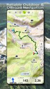
실외 탐색의 주요 기능:
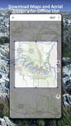
• 오프라인 사용을 위한 지도 데이터 다운로드
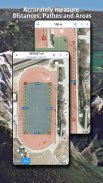
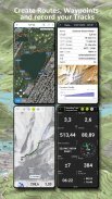
• 경로 및 면적 측정
• 웨이포인트 생성 및 편집
• GoTo-Waypoint-Navigation
• 경로 생성 및 편집
• 경로 탐색(지점 간 탐색)
• 트랙 기록(속도, 고도 및 정확도 프로필 포함)
• 주행거리, 평균 속도, 방위, 고도 등에 대한 필드가 있는 Tripmaster.
• GPX/KML/KMZ 가져오기/내보내기
• 검색(지명, POI, 거리)
• 고도 및 거리 확인
• 지도 보기 및 Tripmaster의 사용자 정의 가능한 데이터 필드(예: 속도, 거리, 나침반 등)
• 웨이포인트, 트랙 또는 경로 공유(이메일, Dropbox, WhatsApp 등을 통해)
• WGS84, UTM 또는 MGRS/USNG(Military Grid/US National Grid)의 좌표를 사용합니다.
• 트랙 재생
• 그리고 더 많은 ...
하이킹, 자전거 타기, 캠핑, 등산, 승마, 스키, 카누, 사냥, 스노모빌 투어, 오프로드 4WD 투어 또는 수색 및 구조(SAR)와 같은 야외 활동에 이 내비게이션 앱을 사용하세요.
WGS84 데이텀을 사용하여 경도/위도, UTM 또는 MGRS/USNG 형식으로 사용자 정의 중간점을 추가합니다.
GPX 또는 Google Earth KML/KMZ 형식으로 GPS-경유지/트랙/경로 가져오기/내보내기/공유.
비가 내리기 시작하거나 멈출 때를 정확하게 예측하려면 애니메이션 NEXRAD 비 레이더를 참조하세요.
질문, 의견, 기능 요청은 support@atlogis.com으로 보내주세요.
US Topo Maps - APK 정보
APK 버전: 7.7.2패키지: com.atlogis.northamerica.freeUS Topo Maps의 최신 버전
다른 버전들


동일 카테고리의 앱


